About the Hamersley project
Why is this project needed?
The Hamersley site is privately owned and has been zoned for urban development. The project will deliver much-needed housing in Perth’s middle-ring suburbs, creating homes close to jobs, schools, and public transport while helping to ease affordability pressures.
The project will establish a significant 19.66-hectare conservation area, permanently protecting and restoring natural bushland for the community’. When the conservation area is no longer used for broadcasting purposes, it will be gifted to the state for long-term conservation.
Why has the project been going for so long?
The project has been undergoing environmental assessment for several years. Comprehensive studies have been completed, including flora, vegetation, fauna, and black cockatoo surveys, to ensure that the most accurate ecological data available to inform the decision-making process.
What is different about the project now, compared to five years ago?
Over the past five years, significant improvements have been made to strengthen the project outcomes. A conservation covenant with strict conditions is now proposed to secure restoration and ensure long-term environmental outcomes.
What is the site used for now?
Currently, a major part of the Hamersley project site houses broadcast infrastructure operated by BAI Communications.
Has this project been assessed by environmental authorities?
The environmental assessment is currently ongoing. The project has undergone years of careful environmental assessment. Detailed reports are available on the Environmental Protection Authority’s (EPA’s) website as well as the Commonwealth Department of Climate Change, Energy, the Environment and Water website.
When will construction commence?
The project is still in the planning stages. We will keep the community informed when key delivery milestones become known.
Environment
Is the site ecologically significant?
Parts of the Hamersley site are ecologically significant, containing areas of native bushland that provide important habitat and biodiversity value.
The land is also privately owned and already zoned for urban development. The state government has no plans to acquire the site for conservation, and nearby state infrastructure upgrades will also result in vegetation clearing.
The Hamersley project has been carefully designed to provide a fair and balanced outcome — allowing for new housing where appropriate, while permanently protecting around 19.6 hectares of high-value bushland through a conservation area. This area will be legally protected and actively managed to support long-term conservation outcomes.
Through this approach, the project delivers both much-needed urban housing and a lasting environmental legacy for the community.
Will Carnaby’s Black Cockatoo habitat be protected?
Yes. Protecting Carnaby’s Black Cockatoo habitat is a key priority for the Hamersley project. Around 19.6 hectares of native bushland will be permanently protected as a conservation area, managed under a long-term environmental plan. This area includes important foraging and habitat trees for Carnaby’s Cockatoos.
Additional revegetation and restoration will also take place on and off site to improve food sources and habitat connections.
All development will occur outside the conservation area, ensuring long-term protection and enhancement of this endangered species’ habitat.
Why is the bushland being cleared?
Ensuring long-term protection of bushland is a key focus of the project, and significant measures will be put in place to protect and restore native bushland.
While some vegetation clearing is necessary for new housing and essential infrastructure upgrades, including roads and sewers, this impact is being balanced by the creation of a 19.66-hectare legally protected conservation area and extensive restoration efforts, ultimately delivering a net positive ecological outcome.
What will happen to the native vegetation and wildlife in the bushland?
A large portion of natural bushland (19.66 hectares) will be permanently protected and restored within the conservation area, safeguarding native bushland and wildlife in perpetuity. On-site restoration will occur within this area, and off-site restoration will also be undertaken to ensure a net positive ecological outcome.
Will the project include greenspace?
Beyond the conservation area, a minimum of 10 per cent of the development area will be dedicated as public open space, which creates opportunity to ensure bushland and significant trees retention within the proposed urban area.
How are we offsetting the loss of bushland?
The project is committed to a net positive ecological outcome. To balance the impact of clearing, the project includes:
- Onsite restoration: Approximately three hectares within the conservation area will be actively restored.
- Offsite restoration: Around 18-20 hectares will be rehabilitated at sites managed by the City of Stirling or the Department of Biodiversity, Conservation and Attractions. These comprehensive offsets mean environmental preservation and investment will extend beyond the project site to deliver wider environmental improvements across the Perth metropolitan area.
Community
Can the public currently access the site?
No, the site has historically been fenced off to the public with no access for the surrounding Hamersley community. As part of the Hamersley project, both the proposed urban area and conservation area will become accessible to the public.
What community consultation has occurred?
Early community consultation occurred in 2019, including holding proactive meetings with local residents to share early plans and gather feedback.
Further opportunities for community consultation will be provided as part of the environmental and planning assessment processes.
How will the project affect traffic in the area?
State-led road upgrades, specifically at the intersection of Erindale Road and Reid Highway, are planned to improve traffic flow and safety. These upgrades will help manage the increased traffic associated with population growth within the area.
Community benefit
How will the development benefit the community?
The Hamersley project delivers multiple community benefits, including new homes close to amenities, a legally protected 19.66-hectare conservation area with public access, public open spaces, a net positive ecological outcome through retention and restoration.
Will there still be green spaces for future generations?
A major part of the project is the creation of a 19.66-hectare conservation area that will be legally protected for the long-term. Additionally, at least 10 per cent of the residential development area will be dedicated to public open space, with significant trees retained.
When will this site be developed?
As this site is yet to be rezoned, there is no development construction schedule.
If the rezoning application is successful, Lot 802 will be sold to a land development company to pursue additional approvals to enable development and then construction.
The community will have several opportunities to provide feedback throughout those subsequent stages.
Who will develop this site?
Cedar Woods Properties, has been selected by BAI Communications as its preferred property development partner to develop Lot 802 for residential purposes, if planning and environmental approvals are granted.
Cedar Woods is a national developer of residential and commercial developments. With award-winning projects in Western Australian, Victoria, Queensland and South Australia, the company has grown to become one of Australia’s leading property companies with a portfolio diversified by geography, price point and product type.
Cedar Woods, has won numerous awards for its environmental excellence and has a strong reputation for being an environmentally and socially responsible developer in Australia.
What is going to be built on this site?
If the rezoning application is approved, a mix of new housing and new public open space could be developed on the site.
After the sale of the land, the new landowner will undertake subsequent planning approvals to determine what can be built on the land.
At present, the application is only to rezone the land.
How many homes will be built on the site?
Before determining the number and types of homes which can potentially be built, the amount of land which can be available for housing will be determined by the outcomes of the current environmental assessment.
Subsequently, the new landowner will have to undergo further statutory planning approvals with the Department of Planning, Lands and Heritage and the City of Stirling.
This process will include additional consultation with the community.
Will the roads around 179 Erindale Road change?
Traffic flow generated from the Hamersley project will depend on the number of houses approved, which is not known at this time.
Any future planning process will require a traffic management strategy which adequately address future traffic requirements to the satisfaction of the Department of Planning, Lands and Heritage and the City of Stirling.
Where is The Hamersley Project located?
The site is located at 179 Erindale Road, Hamersley, Western Australia.
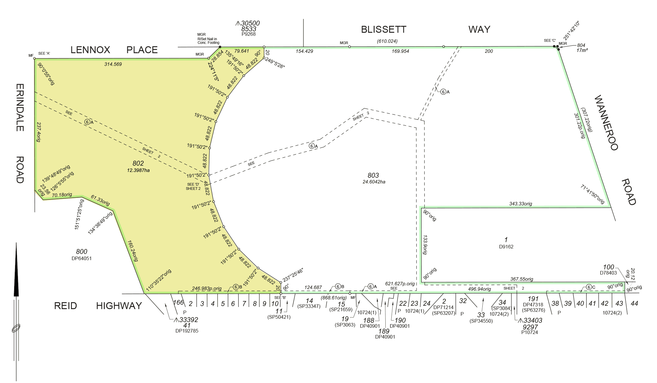
How large is the site?
The Hamersley Project site (Lot 802) is 12.4ha in size.
In 2018, 42 ha of land at 179 Erindale Road was subdivided to create Lot 802 (The Hamersley Project) and Lot 803.
Who owns the site?
BAI Communications is the current landowner.
The land is held by Digital 4 Pty Ltd which is a subsidiary entity of BAI Communications Pty Ltd, that is used for holding its surplus land assets.
How long has BAI Communications owned the site?
BAI Communications acquired 179 Erindale Road in Hamersley, which consists of 42 ha of land, in the 1930s.
What is Lot 802 used for at the moment?
Lot 802 is currently private land, owned by BAI Communications. It is not accessible to the public and is not used for operational purposes.
Why are there applications to have this site rezoned?
The land is surplus to the operational requirements of BAI Communications and as such there is the opportunity to request to rezone the land for a better use.
The land is currently zoned ‘Urban’ under the Metropolitan Region Scheme and zoned as ‘Public Use: Commonwealth’ under the City of Stirling Local Planning Scheme No.3 (LPS3).
Any development to include housing and public open space requires rezoning.
Has the site undergone environmental surveys?
Yes. Seven comprehensive, independent environmental surveys of the site have been conducted since 2017.
Can the community access these surveys?
Yes. Information about The Hamersley Project proposal is available on the Environmental Protection Authority (EPA) website .
More detailed information about the EPA’s referral is available on this webpage. The reference number is 2018/8324.
Who has conducted the environmental site surveys?
The environmental site surveys have been conducted by Strategen / JBS&G ; an accredited, independent environmental consultancy.
Is this a Bush Forever site?
No. The land is not, and never has been, designated as a Bush Forever site. It is privately owned land.
Are there any protected flora and fauna species at the site?
Yes. Some areas on site constitute Black Cockatoo foraging habitat of varying quality and some banksia species have been identified on Lot 802.
A range of environmental mitigation measures to meet and exceed statutory requirements are being proposed to the Commonwealth and State governments as a part of the environmental assessment process.
Is The Hamersley Project removing breeding habitat for the Black Cockatoo?
No black cockatoo breeding is evident from targeted Black Cockatoo surveys conducted on the site.
Specific environmental surveys have been undertaken to determine if tree hollows on site are suitable as Black Cockatoo breeding habitat.
One tree has been identified as having a hollow suitable for breeding. If this tree is determined to be healthy and structurally sound it will be retained as part of any future proposal on the land.
Will there be an environmental management plan for the site?
Yes.
We recognise the environmental features of this site and therefore a significant localised plan is currently being prepared. It will comply with the decision conditions under the Commonwealth’s Environment Protection and Biodiversity Conservation Act 1999 (EPBC Act) and relevant State law including the Environmental Protection Act 1986, the Biodiversity Conservation Act 2016, Planning and Development Act 2005, and associated State and Local Government Planning Policies.
This plan will be made available for public comment via the Environmental Protection Authority (EPA) and the Department of Water, Agriculture and Environment (DAWE) public advertising periods. The applications will publicly advertise for comment when the application is ready.
Is the new landowner going to maintain the environmental features of this site?
Yes. If the application for rezoning is approved, Cedar Woods will become the new landowner and the developer of the site and will be obligated to implement an environmental management response that is consistent with the conditions set by DAWE and the EPA.
Cedar Woods is a highly experienced, respected and environmentally and socially responsible developer in Western Australia.
Cedar Woods, has won numerous awards for its environmental excellence and has a strong reputation for being an environmentally and socially responsible developer in Australia.
Has the community been involved in The Hamersley Project?
Yes. The Hamersley Project team consulted with the community in 2019.
What consultation took place?
This consultation consisted of:
- Establishment of a dedicated website for the project.
- Letters were distributed by mail to more than 500 residents notifying them of drop in sessions on 17 June 2019 and 15 July 2019.
- Two face-to-face drop in sessions on Saturday 29 June 2019 and Saturday 27 July 2019 took place at the Hamersley Community Recreation Centre.
- Advertising of the drop in sessions was published in the local newspaper on 18 June 2019 and 19 July 2019.
- An online survey which was accessible via the project website from 1 June 2019 to 2 August 2019.
- A hard copy survey which was distributed at face-to-face drop in sessions.
The consultation sessions were well attended with 97 community members attending over the two dates.
The Hamersley Project also received feedback in the form of 86 completed surveys. 55% were completed online and 45% were completed in hard copy form at the face-to-face drop in sessions.
What information was presented as a part of the 2019 consultation?
The Hamersley Project team informed the local community about:
- The rezoning process
- The development process
- The site history and ownership
- The local context of the site
- The local movement around the site (roads and access)
- The environmental features of the site
- The town planning scheme amendment process (which was being undertaken in 2019)
- The Structure Plan (a future process the developer will undertake)
Why did The Hamersley Project consult with the community?
The consultation in 2019 was a voluntary process. BAI Communication chose to undertake this early elective consultation with the community to ensure any potential future development takes into consideration its views.
The feedback that was collected will help inform future decisions in relation to the Hamersley Project.
How has The Hamersley Project used this feedback?
There was a range of feedback provided and all items raised will inform future planning applications for the land. Of note was the following:
- Residents on Vickers St who would prefer to retain their existing cul-de-sac however pedestrian and cycle access for improved connectivity was suggested.
- Retention of some of the existing vegetation for mitigation of impacts to local bird species and also for local aesthetics.
- Desire by local residents to ensure a future development would be residential (not commercial) with a mix of detached dwellings and town houses which included adequate areas of public open space.
- Adjacent residents highlighted existing traffic flow and management issues and identified that the impact of this development on local traffic would be very important.
- Local walkability and connectivity were identified as very important and thus the project may provide opportunity to improve connectivity in subsequent detail design stages.
The community will continue to have further opportunities to have their say when the details are worked out as part of subsequent planning processes.